|
Battle of Smithfield Crossing
Other Names: None
Location: Jefferson County and Berkeley County, West Virginia
Campaign: Sheridan's Shenandoah Valley Campaign (August-October 1864)
Date(s): August 25-29,
1864
Principal Commanders: Brig. Gen. Wesley Merritt [US]; Lt. Gen.
Jubal Early [CS]
Forces Engaged: Divisions
Estimated Casualties: 300 total
Result(s): Inconclusive
| Battle of Smithfield Crossing Map |
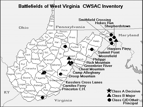
|
| Civil War Smithfield Crossing, West Virginia, Map |
Description: On August 29, two Confederate infantry divisions
crossed Opequon Creek at Smithfield and forced back Merritt’s Union cavalry division back along the road to Charles
Town. Ricketts’s infantry division was brought up to stop the Confederate advance.
Setting the
Stage: West Virginia became a state, breaking away from Virginia during the Civil War, on June 20, 1863. The Battle of Smithfield Crossing was
one of several battles fought during Sheridan's Valley Campaign (August – October 1864). Sheridan's
Valley Campaign, part of the Shenandoah Valley Campaigns of 1864, was the last of three principal campaigns fought throughout the valley region.
Sheridan's Valley Campaign [August-October 1864] witnessed the following battles:
Guard Hill – Summit Point – Smithfield Crossing – Berryville – 3rd Winchester – Fisher's Hill – Tom's Brook – Cedar Creek.
Grant finally lost patience
with Early, particularly his burning of Chambersburg, and knew that Washington remained vulnerable if Early was still on the loose. He found a new commander
aggressive enough to defeat Early: Philip Sheridan, the cavalry commander of
the Army of the Potomac, who was given command of all forces in the area, calling them the
Army of the Shenandoah. Sheridan initially started slowly,
primarily because the impending presidential election of 1864 demanded a cautious approach, avoiding any disaster that might
lead to the defeat of Abraham Lincoln.
| Battle of Smithfield Crossing Map |
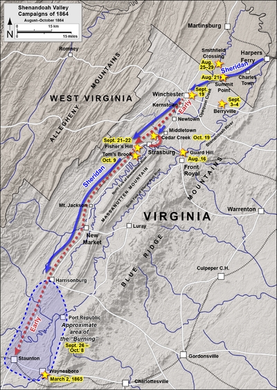
|
| Civil War Battle of Smithfield Crossing and Shenandoah Valley Campaign Map |
Battle: The Battle of Smithfield Crossing was a small battle
during the American Civil War fought August 25 through August 29, 1864, in Jefferson and Berkeley counties in West Virginia.
On August 29, two Confederate infantry divisions under Lieutenant General
Jubal Early crossed Opequon Creek at Smithfield Crossing and forced back Wesley Merritt's Union cavalry division. However,
a counterattack from Ricketts' infantry division stopped the Confederate advance. The results were inconclusive.
During the American Civil War (1861–1865), Berkeley and Jefferson counties, both lying on the Potomac
River east of the mountains, with the consent of the Reorganized Government of Virginia, voted in favor of annexation to West
Virginia in 1863. Many voters absent in the Confederate Army when the vote was taken refused to acknowledge the transfer upon
their return. The Virginia General Assembly repealed the Act of Secession and in 1866 brought suit against West Virginia asking
the court to declare the counties a part of Virginia. Meanwhile, Congress, on March 10, 1866, passed a joint resolution recognizing
the transfer. In 1871, the U.S. Supreme Court decided Virginia v. West Virginia, upholding the secession of West Virginia,
including Berkeley and Jefferson counties, from Virginia.
| Battle of Smithfield Crossing Map |
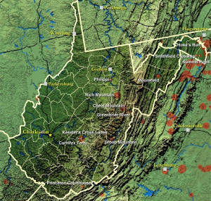
|
| West Virginia Civil War Map |
Civil War History of Jefferson and Berkeley counties
Joining West Virginia: Both Berkeley and Jefferson counties
had voted for secession in the vote taken on May 23, 1861. However, these counties lying on the Potomac River east of the
mountains, with the consent of the Reorganized Government of Virginia supposedly voted in favor of annexation to West Virginia
in 1863 in a dubious election supervised by the occupying Union Army. Virginia tried to nullify this after the American Civil
War, but the counties remained part of West Virginia.
The question of the constitutionality of the formation of the new state
was brought before the Supreme Court of the United States in the following manner: Berkeley and Jefferson County, West Virginia,
counties lying on the Potomac east of the mountains, in 1863, with the consent of the Reorganized Government of Virginia,
had supposedly voted in favor of annexation to West Virginia. However, many voters were absent in the Confederate Army when
the vote was taken and they refused to accept the transfer upon their return. The Virginia General Assembly repealed the Act
of Secession and in 1866 brought suit against West Virginia, asking the Supreme Court to declare the counties still part of
Virginia. Congress, on March 10, 1866, passed a joint resolution recognizing the transfer. In 1871, the U.S. Supreme Court
decided Virginia v. West Virginia, upholding the secession of West Virginia, including Berkeley and Jefferson counties, from
Virginia.
| Jefferson County Map |
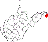
|
| Battle of Smithfield Crossing Map |
Jefferson County and the Civil War: Jefferson
County was formed from Berkeley County in 1801 and named for Thomas Jefferson, author of the Declaration of Independence and
third President of the United States. Virginia previously had a Jefferson County, which was lost to form the new state of
Kentucky. Accordingly, in the State records of Virginia, there will be listings for Jefferson County from 1780-1792 and Jefferson
County from 1801-1863. Neither is still located in Virginia and despite naming a county after him twice, Virginia no longer
has a county named for its hero Thomas Jefferson.
The county's courthouse (often times spelled "court house") was the
site of the trial for the abolitionist John Brown after his October 1859 raid on the federal armory in Harpers Ferry. Some
90 U.S. Marines serving under then Army Colonel Robert E. Lee and Lieutenants J.E.B. Stuart and Israel Green put down the
rebellion.
Brown was sentenced to death for murder, treason against the Commonwealth
of Virginia, and conspiring with slaves to rebel. On December 2, 1859, John Brown was taken from the Charles Town jail
a short distance to an open field and hanged. Among those attending the Brown execution was a contingent of 1500 cadets from
Virginia Military Institute sent by the Governor of Virginia Henry A. Wise under the supervision of Major William Gilham and
Major Thomas J. Jackson. In the ranks of a Richmond militia company stood John Wilkes Booth.
The county was a frequent site of conflict during the Civil War, as Union
and Confederate lines moved back and forth along the Shenandoah valley. Some towns in the county changed hands between the
Union and Confederacy over a dozen times.
Jefferson County is the only part of modern-day West Virginia not exempted
from the effects of the Emancipation Proclamation (as Berkeley County and the 48 counties designated as West Virginia had
been). Slaves in the county were legally free as of January 1, 1863.
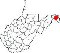
| Berkeley County Map |
|
| Battle of Smithfield Crossing Map |
Berkeley County and the Civil War: Berkeley County
was reduced in size twice during the 19th century. On January 8, 1801, Jefferson County was formed out of the county's eastern
section. Then, on February 9, 1820, Morgan County was formed out of the county's western section and parts of Hampshire County.
Berkeley County was of strategic importance to both the North and the South
during the American Civil War (from 1861 to 1865). The county, and Martinsburg, the county seat, lay at the northern edge
of the Shenandoah Valley, and Martinsburg was very important because the main line of the Baltimore and Ohio Railroad ran
through the town. The rail line was of great importance to both armies. Also, Martinsburg was close to the Union arsenal at
Harpers Ferry. Control over Martinsburg changed hands many times during the war, especially prior to the Battle of Gettysburg
in July 1863. After Gettysburg, the city remained mostly under Union control.
Most of Berkeley County's residents were loyal to the South during the American
Civil War. There were seven companies of soldiers recruited from the county: five for the Confederate Army and two for the
Union Army. At least six hundred men from Berkeley County served in either the Confederate Army or the Union Army.
Berkeley County was also the home of Maria Isabella "Belle" Boyd, a famous
spy for the Confederacy. She was born in Martinsburg on May 9, 1844, and lived there until the outbreak of the war. Her espionage
career began on July 4, 1861 when a band of drunken Union soldiers broke into her Martinsburg home intent on raising the United
States flag over the house. As the soldiers forced their way into the house (one account has a soldier pushing Belle's mother),
Belle drew a pistol and killed him. A board of inquiry exonerated her actions as justifiable homicide, but sentries were posted
around the house and officers kept close track of her activities. She befriended the officers, and at least one of them, Captain
Daniel Keily, shared military secrets with her. She conveyed those secrets to Confederate officers via her slave, Eliza Hopewell,
who carried the messages in a hollowed-out watch case. She later moved to Front Royal, Virginia to live with an aunt. One
evening in mid-May, 1862 General James Shields and his staff conferred in the parlor of the local hotel. Belle hid upstairs
and overheard Shields mentioning that he had been ordered east, a move that would reduce the Union Army's strength at Front
Royal. Belle reported the news to Colonel Turner Ashby, a Confederate scout. He relayed the information to General Thomas
"Stonewall" Jackson, commander of the Confederate Army. After Jackson took Front Royal on May 23, he penned a note of gratitude
to Belle, and named her an honorary Captain. Belle was later arrested by the Union Army for espionage, spent a month in the
Old Capitol Prison in Washington, D.C. and was freed in a prisoner exchange. In June 1863, she was arrested again for espionage
by the Union Army during a visit to Martinsburg. She remained in custody until December 1, 1863 when, suffering from typhoid,
she was allowed to travel to England to regain her strength. While there, she began a stage career and penned her memoirs.
After the war, she returned to the United States, toured the western states recounting her exploits as a spy during the war.
She died in 1900 in Evansville, Wisconsin.
(Sources listed below.)
Sources: National Park Service; Official Records of the Union and Confederate
Armies; Gallagher, Gary W., ed. Struggle for the Shenandoah: Essays on the 1864 Valley Campaign. Kent, OH: Kent State University
Press, 1991. ISBN 0-87338-429-6; Patchan, Scott C. Shenandoah Summer: The 1864 Valley Campaign. Lincoln: University of Nebraska
Press, 2007. ISBN 978-0-8032-3754-4; Cooling, Benjamin Franklin. Jubal Early's Raid on Washington, 1864. Baltimore: Nautical
& Aviation Publishing Company of America, 1989. ISBN 0-933852-86-X; Early, Jubal A., "General Jubal A. Early tells his
story of his advance upon Washington, D.C.". Washington National Republican, 1864; Early, Jubal A. A Memoir of the Last Year
of the War for Independence in the Confederate States of America. Edited by Gary W. Gallagher. Columbia: University of South
Carolina Press, 2001. ISBN 1-57003-450-8; Gallagher, Gary W., ed. The Shenandoah Valley Campaign of 1864. Military Campaigns
of the Civil War. Chapel Hill: University of North Carolina Press, 2006. ISBN 978-0-8078-3005-5; Lewis, Thomas A., and the
Editors of Time-Life Books. The Shenandoah in Flames: The Valley Campaign of 1864. Alexandria, VA: Time-Life Books, 1987.
ISBN 0-8094-4784-3.
|

