|
Kansas Territory History
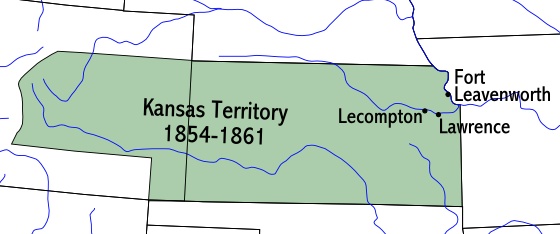
The Territory of Kansas was an organized territory of the United States
that existed from May 30, 1854, to January 29, 1861, when Kansas was admitted into the Union as the 34th U.S. state.
Upon the passage of the Kansas-Nebraska Act on May 30, 1854, the borders of Kansas Territory were set from the Missouri
border to the summit of the Rocky Mountain range; the southern boundary was the 37th parallel, the northern was the 40th parallel.
North of the 40th parallel was Nebraska Territory.
The territory extended from the Missouri border west to the summit of
the Rocky Mountains and from the 37th parallel north to the 40th parallel north. Much of the eastern region of what is now
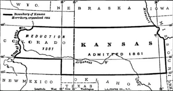
the State of Colorado was part of Kansas Territory. The Colorado Territory, a.k.a. Territory of Colorado, was created to govern this western region of
the former Kansas Territory on February 28, 1861. See also Kansas Civil War History.
| Kansas Territory Map |
|
| Map of the Kansas Territory |
| Kansas Territory Map |
|
| Kansas Statehood Map |
(Sources listed below.)
Bleeding Kansas, Kansas-Missouri
Border War, Kansas-Nebraska Act, Quantrill's Raiders
Sources and Additional Reading: Socolofsky, Homer E. and Huber Self.
(1992) Historical Atlas of Kansas; Wishart, David J. ed. (2004) Encyclopedia of the Great Plains; Castel, Albert.
A Frontier State at War: Kansas, 1861-1865 (1958); Cutler, William G. (1883) History of the State of Kansas; Dick,
Everett. Vanguards of the Frontier: A Social History of the Northern Plains and Rocky Mountains from the Earliest White Contacts
to the Coming of the Homemaker (1941); Goodrich, Thomas. Bloody Dawn: The Story of the Lawrence Massacre (1991); McQuillan,
D. Aidan. (1990) Prevailing over Time: Ethnic Adjustment on the Kansas Prairies, 1875-1925; Miner, Craig. (2002) Kansas:
The History of the Sunflower State, 1854-2000 (ISBN 0-7006-1215-7); Reynolds, David. (2005) John Brown, Abolitionist
(ISBN 0-375-41188-7); Rich, Everett, ed. The Heritage of Kansas: Selected Commentaries on Past Times (1960)
Kansas Territory Maps, Location, History, Details of the Kansas
Territory, When did Kansas become a state, Date of Kansas Statehood, Year Kansas became a state of the United States,
Kansas joined the Union on what date
|
